SKY’S THE LIMIT KENTUCKY
Sky’s The Limit Kentucky specializes in professional real estate photography, drone photography, and aerial videography across Central Kentucky. We capture high-resolution images and cinematic drone video that showcase properties, projects, and landscapes from unique perspectives that stand out in today’s digital marketplace.
01
REAL ESTATE
LISTINGS WITH DRONE IMAGES SELL 65% FASTER
02
CONSTRUCTION
VALUABLE, SAFE, UNIQUE AERIAL PERSPECTIVES
03
EVENTS
CAPTURE SPECIAL EVENTS FROM ABOVE
04
INSPECTIONS
SAFE, RELIABLE, FAST, AND EFFICIENT


WHO WE ARE
AERIAL IMAGES & VIDEO
EFFICIENT PROJECTS. CONSISTENT QUALITY. FAST TURNAROUND
Professional Drone Photography, Aerial Video, and Drone Inspections Across Central Kentucky
Save time, reduce costs, and achieve exceptional results with professional aerial photography and drone video services in Kentucky. Our advanced drone technology captures stunning high-resolution images and cinematic aerial video from perspectives that traditional photography simply cannot achieve.
From real estate marketing and commercial property showcases to construction progress documentation and property inspections, we deliver precise aerial visuals that highlight every detail.
Drone inspections also allow us to safely capture roof, structure, land, and site imagery that would otherwise require ladders, lifts, or scaffolding—reducing risk while improving efficiency.
Serving Frankfort, Lexington, Versailles, Georgetown, Shelbyville, and surrounding Kentucky communities, Sky’s The Limit Kentucky provides reliable aerial media with fast delivery and consistent professional quality.
Real Estate Photography & Video for Listings
Professional Visuals That Attract Buyers and Sell Homes Faster
Today’s homebuyers begin their search online. In fact, nearly 90% of buyers start their home search on the internet, which means your listing photos are often the first impression a property makes.
Professional real estate photography, aerial drone images, and listing videos ensure your property stands out in a competitive market. High-quality interior, exterior, and aerial visuals showcase the home from its most compelling angles, helping buyers immediately connect with the space and envision themselves living there.
Listings with visually engaging photos generate up to 139% more clicks, increasing exposure and buyer interest. Greater listing engagement typically leads to shorter time on market and stronger offers.
Homes marketed with professional real estate photography sell up to 32% faster and can achieve higher sale prices—often averaging 9% more compared to listings without professional imagery.
Sky’s The Limit Kentucky provides professional real estate photography, drone aerial images, and listing videos in Frankfort, Lexington, Versailles, Georgetown, Shelbyville, and surrounding Central Kentucky communities, helping agents and homeowners market properties more effectively.
Safer Documentation. Clear Progress Visibility. Better Project Oversight.
Safer Documentation. Clear Progress Visibility. Better Project Oversight.
Drone technology has become an essential tool for construction progress monitoring and site inspections, providing a safer and more efficient way to document projects from start to finish.
Using professional aerial photography and drone video, construction teams, developers, and project managers gain a clear, comprehensive view of the entire job site. High-resolution aerial imagery captures angles and perspectives that traditional ground photography cannot, allowing stakeholders to monitor progress, verify milestones, and maintain accurate visual records throughout the build process.
The use of small unmanned aircraft systems (sUAS) is recognized for improving safety in environments where access can be difficult or hazardous. Drones allow inspections and documentation to be completed without placing personnel on ladders, scaffolding, or in unsafe areas, reducing risk while improving efficiency.
Whether you need a one-time aerial site inspection or scheduled drone flights to document construction progress over time, Sky’s The Limit Kentucky delivers reliable aerial imagery and video to support project management, reporting, and marketing.
Serving Frankfort, Lexington, Versailles, Georgetown, Shelbyville, and surrounding Central Kentucky communities, we provide professional drone services designed for construction professionals, developers, and property owners.
Clients
Projects Completed
Commercials
Flight Hours
Cities Served
Years Experience
SKILL
OUR EXPERTISE
WHAT CAN WE CAPTURE FROM THE SKY?
Drone technology has transformed the way images and video are captured, providing perspectives that were once only possible with airplanes or helicopters. Today, professional drones allow us to safely and efficiently capture high-resolution aerial photography and cinematic drone video for a wide range of applications.
From real estate marketing and property showcases to construction progress documentation, inspections, land surveys, and event coverage, aerial imagery provides a dynamic perspective that traditional photography cannot match.
At Sky’s The Limit Kentucky, we combine advanced drone technology with professional imaging techniques to deliver clear, visually compelling aerial photos and videos that highlight properties, projects, and landscapes from their most impactful angles.
Serving Frankfort, Lexington, Versailles, Georgetown, Shelbyville, and surrounding Central Kentucky communities, we provide reliable aerial photography and drone video services designed to elevate your project and capture moments from an entirely new perspective.
Sky’s The Limit Kentucky
Buffalo Trace Distillery Drone Photo
Buffalo Trace Distillery in Frankfort, Kentucky
Bridge Inspection Frankfort Kentucky
Bridge construction inspection.
Downtown Frankfort Kentucky
Downtown Frankfort Kentucky with beautiful sunset.
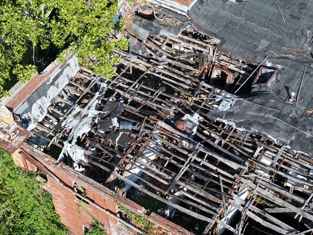
Old Frankfort YMCA in Poor Condition
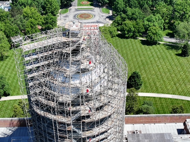
Kentucky Governor's Mansion and beautiful garden landscaping
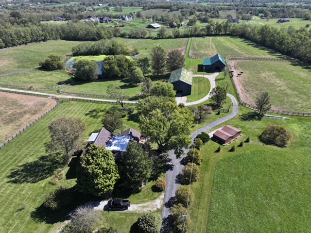
Versailles Kentucky Farm House
Homes leading away from Kentucky Capital in Frankfort Kentucky
BLOG
LATEST UPDATE
NEWS & ARTICLES
No Results Found
The page you requested could not be found. Try refining your search, or use the navigation above to locate the post.